


La Montagne Mille Etangs 7 juillet 2019 OVS

TRIMAILLE
User
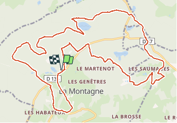

Length
16.9 km

Max alt
818 m

Uphill gradient
425 m
Km-Effort
23 km

Min alt
653 m

Downhill gradient
424 m
Boucle
Yes
Creation date :
2020-06-20 15:19:14.533
Updated on :
2020-07-29 15:18:52.249
4h47
Difficulty : Difficult

FREE GPS app for hiking
 SityTrail
IGN / Geographical institutes
SityTrail Plus
The world is yours!
About
Trail Walking of 16.9 km to be discovered at Bourgogne-Franche-Comté, Haute-Saône, La Montagne. This trail is proposed by TRIMAILLE.
Photos


Positioning
Country:
France
Region :
Bourgogne-Franche-Comté
Department/Province :
Haute-Saône
Municipality :
La Montagne
Location:
Unknown
Start:(Dec)
Start:(UTM)
319631 ; 5310823 (32T) N.
Comments